Since its invention in the first half of the nineteenth century, photography has assumed a leading role as a
means for documenting the real world.
Thanks to the monophotogrammetry image2world allows historical or current, terrestrial or aerial photographs to be used for the quantitative study of the landscape in a wide range of areas.
Some research in the main fields of application are presented in the following examples.
Rapid Mapping
Orthorectification can contribute relatively quickly to the geolocation and reconstruction of event dynamics, and thus also to the organization of search and rescue operations.
Fontana – 2024
During the night from Saturday 29 to Sunday 30 June 2024, a violent thunderstorm swept through the upper Maggia Valley, in the Swiss Alps of Ticino. Precipitation exceeded 120 mm, locally 200 mm, with the epicenter in Bignasco, where 250 mm were recorded. In about one hour, as much water fell locally as normally falls in the whole month of June.
This storm combined with the river already swollen by the late spring snowmelt and the heavy rains of recent weeks, and the saturated soils that no longer allow infiltration, caused unprecedented landslides and flooding throughout the upper Maggia Valley, leaving devastation in its wake.
image2world georeferenced the landslide by orthorectifying a swisstopo photograph taken immediately after the event. The impressive image shows how the landscape has radically changed. The systematic documentation and recording of these events is a very effective way to better understand the phenomena, improving the institutional infrastructure and preventing future damage.
The comparison of before and after the event gives a detailed overview of the catastrophe.
The landslide in Fontana in Val Bavona (Ticino, Switzerland): orthorectification of an aerial photograph taken by swisstopo immediately after the event superimposed on swisstopo 's 2021 orthophoto.
The Zurich train station: comparison of an aerial photograph (taken from a balloon) by Eduard Spelterini from 1904 and the Google Earth image from 2021.
The Sasso Rosso area above the village of Airolo (Canton of Ticino) turned into an unstable
slope due to the decompression caused by post-glacial ice retreat. Local authorities were
aware of this and put the area under surveillance. Initial significant slope movement began in the summer of 1898, followed by three slides of increasing size in December of the same year. Fortunately, the authorities decided at that time to close the school and evacuate the endangered part of the village. Just before midnight in the night of the December 27, 1898, a series of slides occurred, with a volume totaling 500,000 m3, reaching part of the village and destroying a hotel, 11 houses, and 15 stables. According to the perimeter reconstructed from photographs of the time, the affected area of the debris deposit covered about 425,000 m2. (Conedera_etal_2018, Conedera_etal_2013)
Complete photograph on the landslide area.
Projection of the slide perimeter on an oblique terrestrial image of the area prior to the event.
Partial photograph on the landslide area.
Cartography of the perimeter affected by the landslide on a 2012 orthophoto (swisstopo). It is interesting to note how the area covered by the landslide has been abandoned and invaded by the forest.
On May 26, 1896, a landslide deposited 300,000 m3 of material into the Lammbachgraben, creating a natural dam. On May 31, the lake broke through the dam and caused a first huge debris flow, which caused damage to houses and farmland in the Kienholz area. A second flow occurred on the night of June 11-12, while between August 20-23, more debris flows caused extensive damage to residential buildings and the highway, the Brünig railway line and farmland. The layer of debris and mud had a thickness of up to 3 meters. (Conedera_etal_2013)
Debris flow on the 1896 photograph.
Cartography of the perimeter affected by the flow on the 2012 orthophoto (swisstopo).
On the northern side of the Alps, between October 6 and 10, 2011, precipitation ranged from 70 to more than 120 mm. Particularly noteworthy were the amounts of fresh snow that fell between October 8 and 9, when the snowfall limit was still below 1,000 m above sea level. On the morning of October 10, following the arrival of warm, moist air from subtropical latitudes, the snowfall limit rose to over 3000 m above sea level. Marked thawing that led to the melting of fallen snow and new precipitation beginning Oct. 9 caused several floods. On Oct. 10, a landslide in Adelboden obstructed a road and invaded pastures for a width of 120 m from an elevation of 1580 m to 1400 m above sea level. (Conedera_etal_2013)
Debris flow on the 2011 photography.
Cartography of the perimeter affected by the flow on the 2012 national map (swisstopo).
Avalanches and prevention works
Val Bedretto – Villa Bedretto – 1986 (source: Office of Natural Hazards, Ticino, Switzerland)
The month of April 1986 broke all records in Canton Ticino: 25 days of uninterrupted rain with extraordinary amounts of precipitation for the season, 1167 mm at the Camedo measuring station and 667 mm at Locarno-Monti. In the alpine valleys of upper Ticino, 3 to 5 meters of fresh snow was measured, resulting in countless avalanches. Due to the huge number of events and the short duration of the traces of these events, the forestry service of Canton Ticino decided to systematically record avalanches from helicopter flights. (Conedera_etal_2013)C
Avalanches in the Val Bedretto in 1986.
Avalanche cartography in Val Bedretto from 1986 on the 2012 national map (swisstopo).
The functional capability of snow bridges against avalanche detachment highly depends on the correct dimensioning of the supporting structures: for optimal efficiency, snow must not exceed the supporting area of the structure. When these conditions are not satisfied for a significant part of the snow bridge, avalanches can detach from the exceeding snow cover. This was the case in Adelboden during the heavy snowfalls combined with strong snow blowing winds that repeatedly occurred in the winter season of 2017/2018, which caused a partial blanketing of the snow bridges in the upper part of the area in question. On January 24, 2018, 2 days after the end of heavy snowfall, a helicopter mission documented the condition of the snow bridges in exceptional conditions. Mapping the visible parts of the bridges made it possible to identify the parts covered by snowfall, which could potentially fail in their protective function. (Conedera_etal_2018)
Photograph of partially covered snow bridges.
Cartography of snow bridges with snow-covered parts in red.
Landscape study
Channels for wood hauling on old postcards
The use of semi-natural channels to screw timber is a traditional technique of timber harvesting that has been widely documented throughout the Alps. Essentially, it took advantage of the natural conformation of mountain slopes and in particular the presence of small valleys with sufficient slope to allow the spontaneous sliding of wood loads along much of the route. The analysis of the scan of an early 20th century postcard depicting the Melide and Bissone bridge, numerous semi-natural channels for wood hauling can be identified with varying degrees of certitude (green: high reliability, red: low reliability). (Bozzini_etal_2011)
Digitization of wood hauling channels on an early 20th century postcard.
Cartography of the wood hauling channels on the 1:10,000 chorographic plan (Official Measurement of the Canton of Ticino).
Evolution of vegetation: Crana 1910 - 1933 - 2012
At the beginning of the 20th century, the vegetation in the Onsernone Valley was carefully studied and described by the botanist Johann Bär (1877-1957). The final product resulted in a publication that included a detailed 1:50,000 scale colour map (Bär 1918) with considerable detail on the vegetation cover. The photographer Rudolf Zinggeler (1864-1954) visited the Onsernone
Valley and, around 1930, produced several glass plates with extensive panoramic views showing the vegetation cover on the mountain slopes. In 2012, WSL researcher Patrik Krebs rephotographed Zinggeler's photos, as far as possible, from exactly the same position. Digitizing and mapping the different vegetation categories on Bär's map and on the photographs made it possible to compare the state of vegetation in 1910, 1933, and 2012. (Bozzini_etal_2012)
Vegetation at Crana on Bär's map (1910) and photographs by Zinggeler (1933) and Krebs (2012).
Cartography of the different vegetation types in Crana in 1910, 1933 and 2012 on the national map (swisstopo).
Glacier research: the Rhone Glacier 1874-2010
The Rhone Glacier is located in the central Swiss Alps and, like most Alpine glaciers, has been retreating significantly since the mid-19th century. In 2012 at the Swiss Federal Institute of Technology in Zurich, data obtained from a number of photographs were compared with field measurements made systematically since 1974. (Wiesmann_etal_2012)
The Rhone Glacier front from 1874 to 2010 on a 1962 photograph by Hermann Geiger.
Toponymy research
Toponyms, passed down orally over the centuries, reflect a cultural heritage of past land uses, special characteristics of the land, events related to the landscape or inhabitants, and can provide important background information in various scientific fields, such as archaeology, settlement history, people history, economic history, landscape ecology and botany.
Most of the detailed knowledge about traditional place names and their precise localization is non-written and familiar only to old local native persons who experienced the former rural civilization. One of the major problems that one has to face, when trying to trace and document the knowledge related to place names and their localization, is to translate the memory and the former landscape experiences of the respondents into maps and structured records.
Unfortunately, most of these informants are not able to conduct field surveys nor are familiar with map reading and orientation, so that interviews for georeferencing place names on maps are stressful for the informant and time-consuming for the interviewer.
With respect to traditional maps, the use of terrestrial photographs, particularly historical ones, provides a perspective with a point of view closer to human vision and depicts the landscape when rural activity was still predominant. All this facilitates the reading of the land and calls up additional information that increases both the motivation of informants and the accuracy of their statements. (Bozzini_et_al_2013)
Localization of place names on recent orthophotos may reach a good precision, but many places are hardly recognizable due to the advancing forest (Corzoneso 2009 - swisstopo).
Localization of place names on a historical terrestrial picture. The sites are recognizable in their original shape before the abandonment of traditional land-use (Corzoneso 1924 - swisstopo).
Toponymy of Engelberg: Geolocation of place names in Heft Nr. 37 «Orts- und Flurnamen von Engelberg»
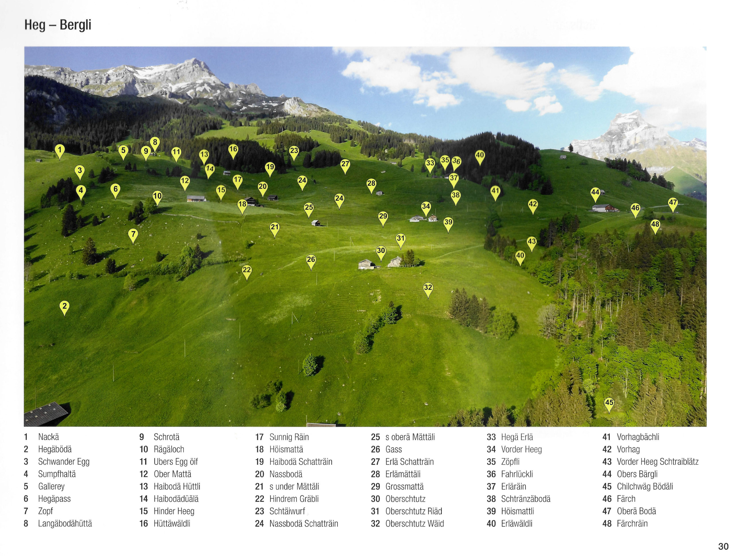
The Engelberg place names geolocation project originates from the Heft Nr. 37 of the 2018 Engelberger Dokumente collection «Orts- und Flurnamen von Engelberg», which features 62 oblique aerial photographs with nearly 2,700 place names represented as points. However, the lack of georeferencing makes it impossible to accurately position these points in space or represent them on a map.
image2worldwas commissioned by the Verein Kulturlandschaft Obwaldento develop a structured workflow to transform this analogue heritage into a georeferenced digital dataset. This involved scanning the pages, verifying and correcting the data using optical character recognition (OCR), and above all, georeferencing the images with the help of official swisstopo cartographic data and digital terrain models.
Analysis revealed the complexity of the task: many place names appear in more than one image, while others exhibit orthographic variations. In total, approximately 1,957 unique place names were identified from 2,689 occurrences.
The project results include a structured database containing unique identifiers, place names, image references and 3D coordinates. This database can be exported in standard GIS formats (such as ESRI Shapefile) and is suitable for both print and digital publications.
Beyond data production, the project opens up new possibilities for enhancing toponymic heritage by enabling place names to be visualized on maps and photographs, integrated into online platforms and enriched with historical information and local contributions.
This work therefore represents a key transition from static documentation to dynamic geographic knowledge, making previously inaccessible cultural heritage both available and usable.
Page 30 of the «Heft» (Hegg - Bergli) with 48 points corresponding to place names.
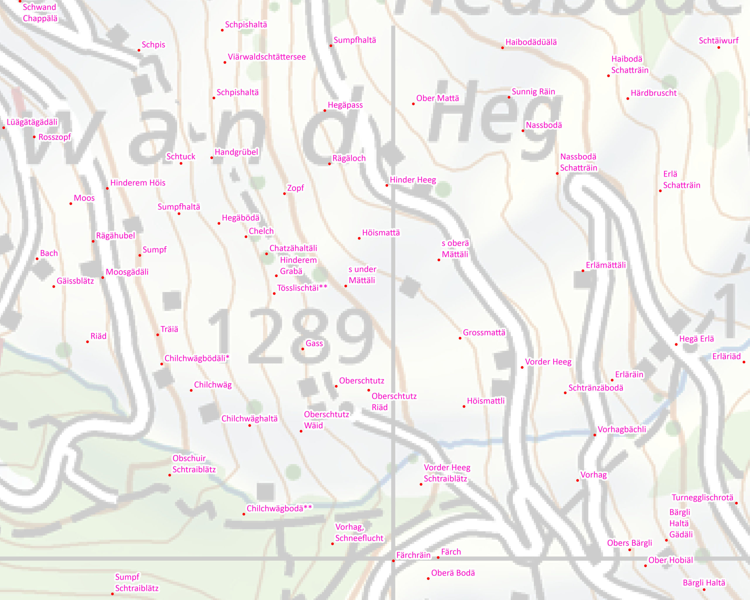
Representation of place names on the Swiss national map.
Heft Nr. 37 of the 2018 Heft Nr. 37 of the 2018 Engelberger Dokumente collection «Orts- und Flurnamen von Engelberg» contains 62 oblique photographs in which the names of places in Engelberg are represented as points and are not geolocated. Thanks to image2world and image georeferencing, 1,957 place names have been geolocated (commissioned by: Verein Kulturlandschaft Obwalden).
Oberberg - Rübimattli (pagina 41): rappresentazione dei nomi di luogo su di una fotografia obliqua.